Blog

Suivez les dernières actualités postées ici !

Codes R dans QGIS pour analyse spatiale

R codes to be used in QGIS and a QGIS plugin to work in Precision Agriculture

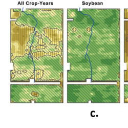
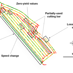
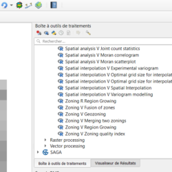
We propose, in Beta version, a set of R codes (more than forty) and a QGIS plugin to manipulate and process data acquired in the framework of Precision Agriculture. The R codes and the QGIS plugin can be retrieved from the Aspexit GitHub account. Remember to read the tutorials to learn how to retrieve the Read more about R codes to be used in QGIS and a QGIS plugin to work in Precision Agriculture[…]

Quantifying the within-field heterogeneity or variability in agriculture

There is no such thing as a perfectly homogenous agricultural field ! And this is simply due to the fact that we work with living organisms and that we are confronted with phenomena that are all more complex than each other (soil, climate, plants, agricultural practices…), and which also have the unfortunate tendency to interact Read more about Quantifying the within-field heterogeneity or variability in agriculture[…]

Reflecting on the carbon footprint of digital technologies in the AgTech and Precision Agriculture sectors

The International Society for Precision Agriculture (ISPA), proposed a definition of Precision Agriculture in 2019 following exchanges between 45 scientists from around the world: “Precision Agriculture is a management strategy that collects, processes and analyzes spatial, temporal and individual data, and combines them with other information to guide adaptive management decisions related to the plant Read more about Reflecting on the carbon footprint of digital technologies in the AgTech and Precision Agriculture sectors[…]

Le géo positionnementven agriculture

Geo-positioning in agriculture

As you are no doubt aware, geo-positioning has been a particularly powerful lever for many agricultural applications and crop itineraries. But are you clear on the extent of geo-positioning systems, tools and methods? If you’re French, you should be crazy about abbreviations – so hang on : GPS, GNSS, EGNOS, DOP, TTF, SBAS, LBAS, WAAS, Read more about Geo-positioning in agriculture[…]

Linear modelling of spatial data in R

We will work here on a dataset that is fairly well known in spatial analysis – the “meuse” dataset – in order to reintroduce a number of concepts to those who would like to engage in linear modelling of spatialized data. This case study will be treated under the R language. One of the big Read more about Linear modelling of spatial data in R[…]

Coordinate reference systems

If there is one subject that is neglected when working with spatialized data, it is the reference coordinate system. In general, we try to spend as little time as possible on the subject – often because it’s not very clear – and assume that we have collected our data in a super coordinate system or Read more about Coordinate reference systems[…]

How to generate spatially correlated data?

Generally speaking, when we want to evaluate the robustness and/or generality of an algorithm, we need to test it on a large number of data, with quite varied characteristics, to ensure that the algorithm will give conclusive results in the vast majority of cases. If we had the means to have real data or field Read more about How to generate spatially correlated data?[…]

Working with high-resolution data in precision agriculture

Precision Agriculture is a data-based discipline; data that is collected to measure, describe, quantify, understand, or analyze agrosystems. A wide variety of measurement systems have been developed to measure agronomic parameters of interest, from plant vegetation status to crop yield, including weed detection and soil physico-chemical parameters. These increasingly sophisticated systems make it possible to Read more about Working with high-resolution data in precision agriculture[…]

Producing profitability maps from yield maps?

In spite of the emulation around precision agriculture and digital agriculture in France, it is clear that these tools and solutions are not yet widespread in the field. Some recent statistics from the French observatory of digital uses in agriculture can testify to this: less than 10% of farmers used variable-rate tools in 2018, as few Read more about Producing profitability maps from yield maps?[…]

Filtering – Cleaning Yield Maps

In the previous post, a fairly general picture of yield sensors and associated data was drawn. Here we return to a recurring question related to yield data: How can we ensure that yield data are reliable enough to be used properly? We will therefore review the main sources of uncertainty in these data sets; and Read more about Filtering – Cleaning Yield Maps[…]